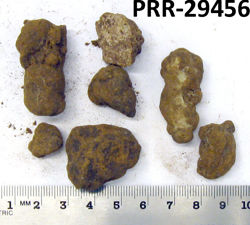
Object # PRR-29456: Dredge
| Primary Field # | ELT06-13C-04 [3] |
| IGSN # | PRR029456 |
| Kind of Object | Dredge |
| Rock Type | Sedimentary |
| Rock Name | Manganese Nodules |
| Weight | 123 g |
| General Notes | 10' Blake Trawl. Mn stained glacial erratic pebbles. [the 3 ring binder of records states the start and stop latitude is 57 57' and 58 43', that is a large distance to cover during 5 hours of trawling, it is likely a typo and should be either 57 43' as an ending latitude - or 58 57' as a starting latitude] |
| Ocean/Sea | Scotia Sea |
| Coordinates | -57.950, -55.950 (57° 57' S, 55° 57' W) |
| Surface Features | Manganese staining |
| Primary Field Logistics | Ship (Eltanin) |
| Data Sources | 1971 Inventory of Rock Samples from Antarctic seas. Cruises 3 to 45 of USNS Eltanin. Geology Section, Smithsonian Oceanographic Sorting Center (SOSC) USNS Eltanin Marine Geology Cruises 1 to 8 |
| Date Collected | 1962-12-28 |
| Field Year Collected | 1962 |
| Donor | Florida State University |
| Vessel Name | Eltanin |
| Cruise Number | 6 |
| Ship Station Number | 13 C |
| Rock Station Number | 4 |
| ADDL # | 0393 |
| Starting Depth (mbsl) | 4005 |
| Finishing Depth (mbsl) | 3987 |
| Dredge Sampling Device | Blake Trawl |
| Dredging Coordinates | -57.950, -55.950 (57° 57' S, 55° 57' W) ➞ -58.717, -55.783 (58° 43' S, 55° 47' W) |
If you would like a 3D scan of this sample, please contact the Curator.
Cite as:
The Polar Rock Repository (PRR), Byrd Polar and Climate Research Center (BPCRC), Ohio State University: Polar rock and dredge samples available for research and educational use from the PRR.
doi:10.7289/V5RF5S18 [date of access]