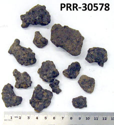
Object # PRR-30578: Dredge
| Primary Field # | ELT10-30 MT10-20 |
| Secondary Field # | ARF000604 |
| IGSN # | PRR030578 |
| Kind of Object | Dredge |
| Rock Type | Sedimentary |
| Rock Name | Manganese Nodules |
| Weight | 890 g |
| General Notes | Mn nodules, 1 to 5cm, agglutinated pebble variety |
| Ocean/Sea | Pacific Ocean |
| Coordinates | -58.293, -78.460 (58° 17.6' S, 78° 27.6' W) |
| Elevation is Approximate | Yes |
| Surface Features | Manganese staining |
| Primary Field Logistics | Ship (Eltanin) |
| Data Sources | Label USNS Eltanin Marine Geology Cruises 9 to 15 |
| Date Collected | 1963-11-25 |
| Field Year Collected | 1963 |
| Donor | Florida State University |
| Vessel Name | Eltanin |
| Cruise Number | 10 |
| Ship Station Number | 30 |
| Rock Station Number | 20 |
| ADDL # | 0870 |
| Starting Depth (mbsl) | 4938 |
| Dredge Sampling Device | Menzies Trawl |
| Dredging Coordinates | -58.293, -78.460 (58° 17.6' S, 78° 27.6' W) ➞ -58.293, -78.460 (58° 17.6' S, 78° 27.6' W) |
If you would like a 3D scan of this sample, please contact the Curator.
Cite as:
The Polar Rock Repository (PRR), Byrd Polar and Climate Research Center (BPCRC), Ohio State University: Polar rock and dredge samples available for research and educational use from the PRR.
doi:10.7289/V5RF5S18 [date of access]