Object # PRR-30991: Dredge
| Primary Field # | ELT15-08 BT15-05 |
| Secondary Field # | ARF000796 |
| IGSN # | PRR030991 |
| Kind of Object | Dredge |
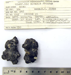
| Rock Type | Sedimentary |
| Rock Name | Manganese Nodules |
| Sample Description | [3 clasts] |
| Weight | 46 g |
| General Notes | Bottom echo on the PDR was very flat. Bottom photos showed extensive coverage of the bottom by manganese nodules. Sample was almost exclusively manganese nodules which were is some cases just manganese coating on igneous rocks but the majority of the nodules had centers of pumice or undeterminable nuclei. |
| Ocean/Sea | Southern Ocean |
| Coordinates | -61.100, -104.967 (61° 6' S, 104° 58' W) |
| Elevation is Approximate | Yes |
| Surface Features | Manganese staining |
| Primary Field Logistics | Ship (Eltanin) |
| Data Sources | SOSC Card USNS Eltanin Marine Geology Cruises 9 to 15 3 ring binder 3 ring binder |
| Date Collected | 1964-10-22 |
| Field Year Collected | 1964 |
| Donor | Florida State University |
| Vessel Name | Eltanin |
| Cruise Number | 15 |
| Ship Station Number | 8 |
| Rock Station Number | 5 |
| ADDL # | 1311 |
| Starting Depth (mbsl) | 4883 |
| Finishing Depth (mbsl) | 4828 |
| Dredge Sampling Device | Blake Trawl |
| Dredging Coordinates | -61.100, -104.967 (61° 6' S, 104° 58' W) ➞ -61.117, -104.967 (61° 7' S, 104° 58' W) |
If you would like a 3D scan of this sample, please contact the Curator.
Cite as:
The Polar Rock Repository (PRR), Byrd Polar and Climate Research Center (BPCRC), Ohio State University: Polar rock and dredge samples available for research and educational use from the PRR.
doi:10.7289/V5RF5S18 [date of access]