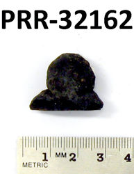
Object # PRR-32162: Dredge
| Primary Field # | E12-15, BT12-12 |
| IGSN # | PRR032162 |
| Kind of Object | Dredge |
| Rock Type | Sedimentary |
| Rock Name | Manganese Nodules |
| Weight | 8 g |
| Ocean/Sea | Scotia Sea |
| Coordinates | -60.610, -29.978 (60° 36.6' S, 29° 58.7' W) |
| Elevation is Approximate | Yes |
| Primary Field Logistics | Ship (Eltanin) |
| Data Sources | Label USNS Eltanin Marine Geology Cruises 9 to 15 |
| Date Collected | 1964-04-02 |
| Field Year Collected | 1964 |
| Donor | Florida State University |
| Vessel Name | Eltanin |
| Cruise Number | 12 |
| Ship Station Number | 15 |
| Rock Station Number | 12 |
| ADDL # | 1054 |
| Starting Depth (mbsl) | 878 |
| Finishing Depth (mbsl) | 1079 |
| Dredge Sampling Device | Blake Trawl |
| Dredging Coordinates | -60.610, -29.978 (60° 36.6' S, 29° 58.7' W) ➞ -60.622, -29.950 (60° 37.3' S, 29° 57' W) |
If you would like a 3D scan of this sample, please contact the Curator.
Cite as:
The Polar Rock Repository (PRR), Byrd Polar and Climate Research Center (BPCRC), Ohio State University: Polar rock and dredge samples available for research and educational use from the PRR.
doi:10.7289/V5RF5S18 [date of access]