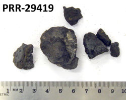
Object # PRR-29419: Dredge
| Primary Field # | ELT06-09A-09 |
| IGSN # | PRR029419 |
| Kind of Object | Dredge |
| Rock Type | Sedimentary |
| Rock Name | Manganese Nodules |
| Sample Description | Double layer nodules with core outer crust |
| Weight | 42 g |
| General Notes | Very rough bottom, local relief 180 fathoms. Sedimentary - shale, chips and well rounded pebbles; Igneous: granite, diorite, gabbro; calcite filling of one pebble; many spherical Mn nodules. |
| Ocean/Sea | South Atlantic Ocean |
| Continent | South America |
| Precise Location | Burdwood Bank |
| Coordinates | -54.050, -56.083 (54° 3' S, 56° 5' W) |
| Surface Features | Manganese staining |
| Primary Field Logistics | Ship (Eltanin) |
| Data Sources | 1971 Inventory of Rock Samples from Antarctic seas. Cruises 3 to 45 of USNS Eltanin. Geology Section, Smithsonian Oceanographic Sorting Center (SOSC) USNS Eltanin Marine Geology Cruises 1 to 8 |
| Date Collected | 1962-12-20 |
| Field Year Collected | 1962 |
| Donor | Florida State University |
| Vessel Name | Eltanin |
| Cruise Number | 6 |
| Ship Station Number | 9 A |
| Rock Station Number | 9 |
| ADDL # | 0376 |
| Starting Depth (mbsl) | 1719 |
| Finishing Depth (mbsl) | 1737 |
| Dredge Sampling Device | Rock Dredge |
| Dredging Coordinates | -54.050, -56.083 (54° 3' S, 56° 5' W) ➞ -54.050, -56.050 (54° 3' S, 56° 3' W) |
If you would like a 3D scan of this sample, please contact the Curator.
Cite as:
The Polar Rock Repository (PRR), Byrd Polar and Climate Research Center (BPCRC), Ohio State University: Polar rock and dredge samples available for research and educational use from the PRR.
doi:10.7289/V5RF5S18 [date of access]