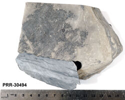
Object # PRR-30494: Dredge
| Primary Field # | ELT09-18A-12 |
| Secondary Field # | ARF0006G3 |
| IGSN # | PRR030494 |
| Kind of Object | Dredge |
| Rock Type | sedimentary |
| Rock Name | Siltstone |
| Sample Description | [gray siltstone; paleomagnetic drill hole] |
| Weight | 652 g |
| Susceptibility | 16 x10-5 SI units |
| General Notes | Seamount, irregular with slight saddle |
| Ocean/Sea | Scotia Sea |
| Coordinates | -58.875, -36.400 (58° 52.5' S, 36° 24' W) |
| Elevation is Approximate | Yes |
| Primary Field Logistics | Ship (Eltanin) |
| Data Sources | Label USNS Eltanin Marine Geology Cruises 9 to 15 |
| Date Collected | 1963-09-02 |
| Field Year Collected | 1963 |
| Donor | Florida State University |
| Vessel Name | Eltanin |
| Cruise Number | 9 |
| Ship Station Number | 18 A |
| Rock Station Number | T-12 |
| ADDL # | 0709 |
| Starting Depth (mbsl) | 1737 |
| Finishing Depth (mbsl) | 1783 |
| Dredge Sampling Device | Menzies Trawl |
| Dredge Sampling Device 2 | Blake Trawl |
| Dredging Coordinates | -58.875, -36.400 (58° 52.5' S, 36° 24' W) ➞ -58.767, -36.383 (58° 46' S, 36° 23' W) |
If you would like a 3D scan of this sample, please contact the Curator.
Cite as:
The Polar Rock Repository (PRR), Byrd Polar and Climate Research Center (BPCRC), Ohio State University: Polar rock and dredge samples available for research and educational use from the PRR.
doi:10.7289/V5RF5S18 [date of access]