Object # PRR-30925: Dredge
| Primary Field # | ELT15-15 BT15-8 |
| Secondary Field # | ARF0007A7 |
| IGSN # | PRR030925 |
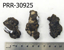
| Kind of Object | Dredge |
| Rock Type | Sedimentary |
| Rock Name | Manganese Nodules |
| Sample Description | [~80 clasts] |
| Weight | 1930 g |
| Susceptibility | 68 x10-5 SI units |
| General Notes | Moderate relief with the bottom photos showing mud and nodules. 80% of the sample consisted of manganese nodules and other rocks have a substantial manganese crust. The remaining 20% are basalts, granites, quartzites and one piece of shale. |
| Ocean/Sea | Pacific Ocean |
| Coordinates | -57.150, -119.550 (57° 9' S, 119° 33' W) |
| Elevation is Approximate | Yes |
| Surface Features | Manganese staining |
| Primary Field Logistics | Ship (Eltanin) |
| Data Sources | Label USNS Eltanin Marine Geology Cruises 9 to 15 3 ring binder |
| Date Collected | 1964-11-02 |
| Field Year Collected | 1964 |
| Donor | Florida State University |
| Vessel Name | Eltanin |
| Cruise Number | 15 |
| Ship Station Number | 15 |
| Rock Station Number | 8 |
| ADDL # | 1335 |
| Starting Depth (mbsl) | 4517 |
| Finishing Depth (mbsl) | 4499 |
| Dredge Sampling Device | Blake Trawl |
| Dredging Coordinates | -57.150, -119.550 (57° 9' S, 119° 33' W) ➞ -57.167, -119.517 (57° 10' S, 119° 31' W) |
If you would like a 3D scan of this sample, please contact the Curator.
Cite as:
The Polar Rock Repository (PRR), Byrd Polar and Climate Research Center (BPCRC), Ohio State University: Polar rock and dredge samples available for research and educational use from the PRR.
doi:10.7289/V5RF5S18 [date of access]